Artvee
  • Browse
    • Abstract
    • Figurative
    • Landscape
    • Illustration
    • Posters
    • Religion
    • Mythology
    • Still Life
    • Nature
    • Drawings
  • Books
  • Artists
  • Explore
    • Topics
    • Culture
    • Movements
  • Highlights
  • Collections
  • Galleries
  • Artvee Pro
Login
Artvee
Menu
Carl Diercke
Carl Diercke

Carl Diercke

German, 1842-1913
Follow

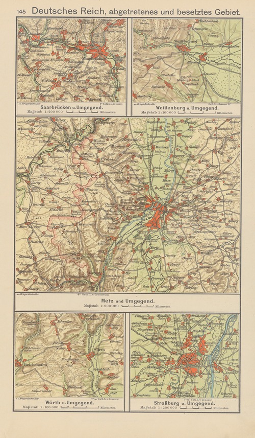
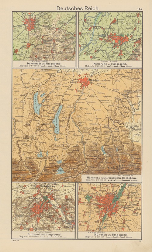
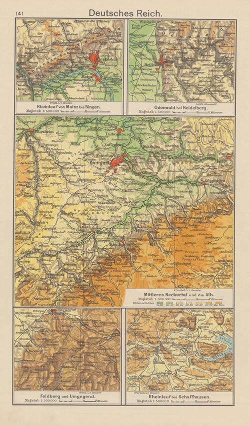
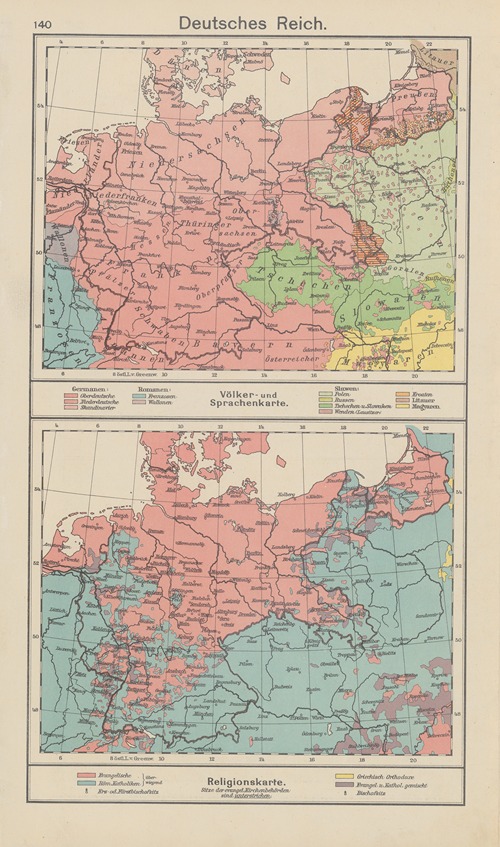
Carl Diercke was a German educator and cartographer. He was the creator of the widely known Diercke School Atlas, which was initially continued by his son Paul Diercke and is now published as the Diercke World Atlas by the Westermann Printing and Publishing Group in Braunschweig.

Carl Diercke was born to innkeeper and brewery owner Carl Friedrich Daniel Diercke and Louise Dorothee, née Müller. After the early death of his father, his mother married a former teacher. As the family moved frequently, the boy attended schools in Kyritz, Salzwedel, and Berlin.

After graduating from high school, Diercke trained as a teacher in Berlin from 1860 to 1863, where he passed his exams to qualify as a teacher of chemistry, French, geography, geometry, Latin, natural history, pedagogy, and arithmetic between 1863 and 1865. He began his professional career in 1865 as a private tutor in Riga, which was then part of the Russian Empire. He remained there until 1869, before being appointed as a seminar teacher in Berlin in 1870.

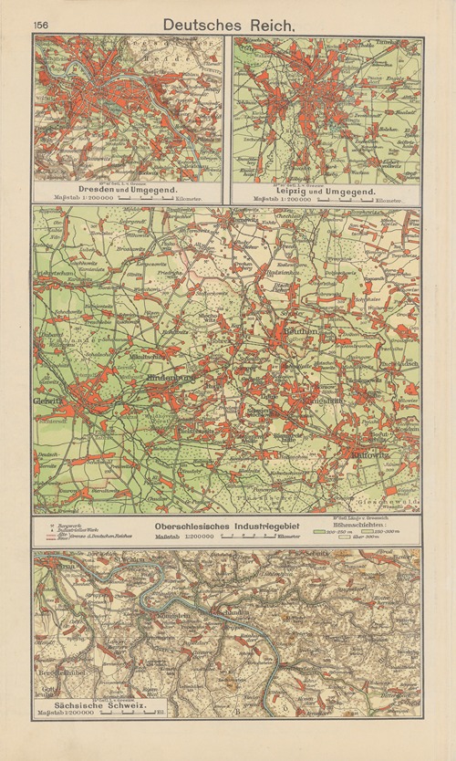
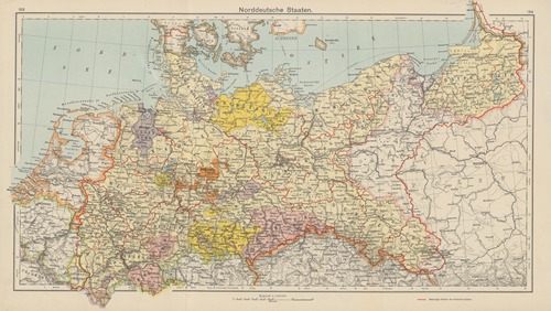
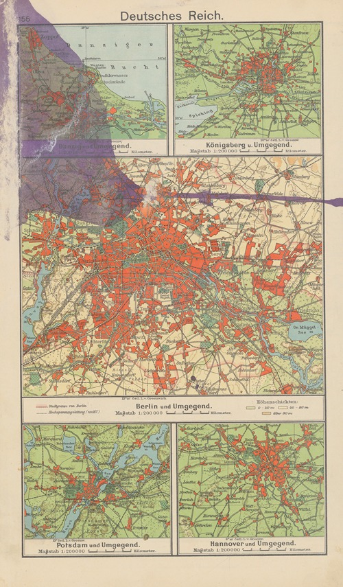
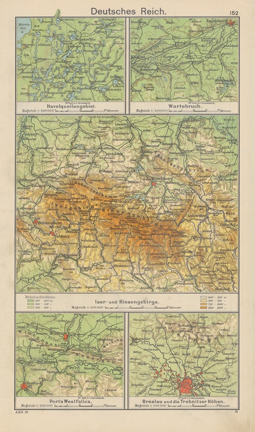
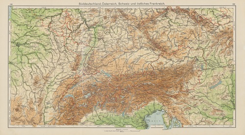
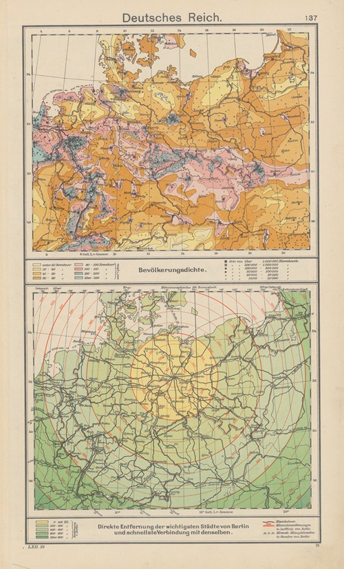
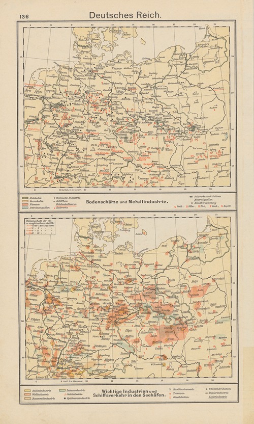
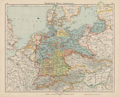
In Berlin, he met Hermine Marie Ottilie Lucas, whom he married in 1871. The couple had eight children, including sons Carl Wilhelm Heinrich (1872–1915) and Paul (1874–1937). In 1873, Diercke was transferred to Stade as a seminar teacher and a year later was appointed director of the royal teacher training college for elementary school teachers there. His interest and favorite subject here became geography, and he began to draw his own maps, which were clear and concise and therefore particularly suitable for children.

Diercke's success led to his appointment as director of the teacher training college in Osnabrück in 1885. In addition, the Prussian Ministry of Spiritual, Educational, and Medical Affairs appointed him as a government and school inspector. From 1899 to 1908, he held the position of school director in Schleswig, where he was appointed Privy Councilor in 1904.

In 1907, his wife Ottilie died and was buried in Schleswig. In 1908, Carl Diercke retired and was awarded the Hohenzollern House Order 3rd Class on this occasion. In the same year, he moved to the then still independent town of Wilmersdorf, where he died at the age of 70. At his request, he was buried in Schleswig-Friedrichsberg on March 11, 1913.

One of his descendants still alive today is Arnold Willemer.

124 items

Show 30 50 70
Deutsches‎ ‎Reich

Deutsches‎ ‎Reich (1930)

Carl Diercke (German, 1842-1913)
Illustration
Norddeutsche‎ ‎Staaten

Norddeutsche‎ ‎Staaten (1930)

Carl Diercke (German, 1842-1913)
Illustration
Deutsches‎ ‎Reich

Deutsches‎ ‎Reich (1930)

Carl Diercke (German, 1842-1913)
Illustration
Deutsches‎ ‎Reich

Deutsches‎ ‎Reich (1930)

Carl Diercke (German, 1842-1913)
Illustration
Deutsches‎ ‎Reich

Deutsches‎ ‎Reich (1930)

Carl Diercke (German, 1842-1913)
Illustration
Deutsches‎ ‎Reich, Siedelungsbeispiele

Deutsches‎ ‎Reich, Siedelungsbeispiele (1930)

Carl Diercke (German, 1842-1913)
Illustration
Norddeutschland

Norddeutschland (1930)

Carl Diercke (German, 1842-1913)
Illustration
Deutsches‎ ‎Reich, Siedelungsbeispiele

Deutsches‎ ‎Reich, Siedelungsbeispiele (1930)

Carl Diercke (German, 1842-1913)
Illustration
Deutsches‎ ‎Reich

Deutsches‎ ‎Reich (1930)

Carl Diercke (German, 1842-1913)
Illustration
Deutsches‎ ‎Reich

Deutsches‎ ‎Reich (1930)

Carl Diercke (German, 1842-1913)
Illustration
Deutsches‎ ‎Reich, abgetretenes und besetztes Gebiet

Deutsches‎ ‎Reich, abgetretenes und besetztes Gebiet (1930)

Carl Diercke (German, 1842-1913)
Illustration
Süddeutschland,‎ ‎Österreich,‎ ‎Schweiz‎ ‎und‎ ‎östliches‎ ‎Frankreich

Süddeutschland,‎ ‎Österreich,‎ ‎Schweiz‎ ‎und‎ ‎östliches‎ ‎Frankreich (1930)

Carl Diercke (German, 1842-1913)
Illustration
Deutsches‎ ‎Reich, abgetretenes und besetztes Gebiet

Deutsches‎ ‎Reich, abgetretenes und besetztes Gebiet (1930)

Carl Diercke (German, 1842-1913)
Illustration
Deutsches‎ ‎Reich

Deutsches‎ ‎Reich (1930)

Carl Diercke (German, 1842-1913)
Illustration
Deutsches‎ ‎Reich

Deutsches‎ ‎Reich (1930)

Carl Diercke (German, 1842-1913)
Illustration
Deutsches‎ ‎Reich; Völker-‎ ‎und‎ ‎Sprachenkarte.‎ ‎—‎ ‎Religionskarte

Deutsches‎ ‎Reich; Völker-‎ ‎und‎ ‎Sprachenkarte.‎ ‎—‎ ‎Religionskarte (1930)

Carl Diercke (German, 1842-1913)
Illustration
Süddeutschland,‎ ‎Österreich,‎ ‎Schweiz‎ ‎und‎ ‎östliches‎ ‎Frankreich

Süddeutschland,‎ ‎Österreich,‎ ‎Schweiz‎ ‎und‎ ‎östliches‎ ‎Frankreich (1930)

Carl Diercke (German, 1842-1913)
Illustration
Deutsches‎ ‎Reich; Bevölkerungsdichte.‎ ‎—‎ ‎Direkte‎ ‎Entfernung‎ ‎der‎ ‎wichtigsten‎ ‎Städte‎ ‎von‎ ‎Berlin

Deutsches‎ ‎Reich; Bevölkerungsdichte.‎ ‎—‎ ‎Direkte‎ ‎Entfernung‎ ‎der‎ ‎wichtigsten‎ ‎Städte‎ ‎von‎ ‎Berlin (1930)

Carl Diercke (German, 1842-1913)
Illustration
Deutsches‎ ‎Reich; Bodenschätze‎ ‎und‎ ‎Metallindustrie.‎ ‎—‎ ‎Wichtige‎ ‎Industrien‎ ‎und‎ ‎Schiffsverkehr‎ ‎in‎ ‎den‎ ‎Seehäfen

Deutsches‎ ‎Reich; Bodenschätze‎ ‎und‎ ‎Metallindustrie.‎ ‎—‎ ‎Wichtige‎ ‎Industrien‎ ‎und‎ ‎Schiffsverkehr‎ ‎in‎ ‎den‎ ‎Seehäfen (1930)

Carl Diercke (German, 1842-1913)
Illustration
Deutsches‎ ‎Reich; Staatenkarte

Deutsches‎ ‎Reich; Staatenkarte (1930)

Carl Diercke (German, 1842-1913)
Illustration
Deutsches‎ ‎Reich; Regenkarte.‎ ‎—‎ ‎Bodenbenutzung

Deutsches‎ ‎Reich; Regenkarte.‎ ‎—‎ ‎Bodenbenutzung (1930)

Carl Diercke (German, 1842-1913)
Illustration
Deutsches‎ ‎Reich; Temperaturkarte.‎ ‎—‎ ‎Phänologische‎ ‎Karte

Deutsches‎ ‎Reich; Temperaturkarte.‎ ‎—‎ ‎Phänologische‎ ‎Karte (1930)

Carl Diercke (German, 1842-1913)
Illustration
Deutsches‎ ‎Reich

Deutsches‎ ‎Reich (1930)

Carl Diercke (German, 1842-1913)
Illustration
Deutsches‎ ‎Reich

Deutsches‎ ‎Reich (1930)

Carl Diercke (German, 1842-1913)
Illustration
Polen

Polen (1930)

Carl Diercke (German, 1842-1913)
Illustration
Polen

Polen (1930)

Carl Diercke (German, 1842-1913)
Illustration
Donau-Staaten; Wien‎ ‎und‎ ‎Umgegend—‎ ‎Schlachtfeld‎ ‎von‎ ‎Königgrätz‎—‎ ‎Hohe‎ ‎Tatra- Semmeringbahn

Donau-Staaten; Wien‎ ‎und‎ ‎Umgegend—‎ ‎Schlachtfeld‎ ‎von‎ ‎Königgrätz‎—‎ ‎Hohe‎ ‎Tatra- Semmeringbahn (1930)

Carl Diercke (German, 1842-1913)
Illustration
Donau-Staaten

Donau-Staaten (1930)

Carl Diercke (German, 1842-1913)
Illustration
Donau-Staaten; Völkerkarte.‎ ‎—‎ ‎Religionskarte.‎ ‎—‎ ‎Bevölkerungsdichte

Donau-Staaten; Völkerkarte.‎ ‎—‎ ‎Religionskarte.‎ ‎—‎ ‎Bevölkerungsdichte (1930)

Carl Diercke (German, 1842-1913)
Illustration
Donau-Staaten; Regenkarte.‎ ‎—‎ ‎Bodenbenutzung.‎ ‎—‎ ‎Bodenschätze‎ ‎und‎ ‎Industrie

Donau-Staaten; Regenkarte.‎ ‎—‎ ‎Bodenbenutzung.‎ ‎—‎ ‎Bodenschätze‎ ‎und‎ ‎Industrie (1930)

Carl Diercke (German, 1842-1913)
Illustration
  • 1
  • 2
  • 3
  • 4
  • 5
  • →

0 Artworks
Follow
Facebook Twitter Pinterest
Favourite
Collect

Standard, JPG, Size:

Download

Max Size, JPG, Size:

Download
License: All public domain files can be freely used for personal and commercial projects. .
Why is this image in the public domain?
  • Terms
  • Privacy
  • Contact us
Artvee.com 2024 All Rights Reserved
We use cookies to improve your experience on our website. By browsing this website, you agree to our use of cookies.
More info Accept
  • Sign in
  • Browse
    • Abstract
    • Figurative
    • Landscape
    • Illustration
    • Posters
    • Religion
    • Mythology
    • Still Life
    • Nature
    • Drawings
  • Artists
  • Books
  • Explore
    • Topics
    • Culture
    • Movements
  • Highlights
  • Collections
  • Galleries
  • Artvee Pro